


THE ROMAN ROAD
After a short jump in time of “only” three to four thousand and a few years (at the end of the day, time is a relative concept 😊), we will reach the Roman times. With their immense military power but as well, and without any doubt, with a gigantic cultural contribution, they had followers wherever they arrived. In the Iberian Peninsula they developed a roads network of more than 40,000 km, as wonderfully described by D. Pau Soto, historian/Archaeologist at the Institut Catalá d’Arqueología Clássica (ICAC) in his History of Mobility in the Iberian Peninsula through the Roman roads. One of them runs parallel to the young Guadiana River and therefore crosses our farm, PAGO LOS CERRILLOS. Little of it remains nowadays but a little bit of its original layout.
THE MAP OF HISPANIA
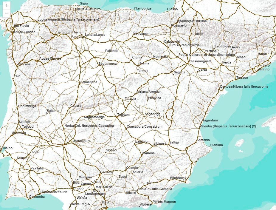
In the case of Hispania, the first roads built by the Romans, primarily for military use, date back to around 120 BC in the Catalonia region. As they conquered the Peninsula, they shaped an impressive network of road infrastructure, as can be seen in the map created by Pau de Soto. Some of the most important were the Via Augusta, about 1,500 kilometers long and running from Cádiz to the Pyrenees bordering the Mediterranean, or the Via de la Plata, from Augusta Emerita (Mérida) to Asturica Augusta (Astorga).
Another essential epigraphic element for understanding the layout of Roman roads are the milestones, cylindrical stone columns between 2 and 4 metres high that indicated the number of miles from their location, especially on bridges, nearby temples or monumental arches at the entrance to cities, to the point of origin of the road where they were located, which generally started in a town. They could also indicate the distance to a fork in the road or a geographical feature.
Furthermore, some of these milestones, which were like ancient traffic signs, indicated the name of the authority who commissioned the construction or repair of the road and, therefore, the period of its completion. Based on this information, the greatest volume of road construction in Hispania was recorded when Trajan and Hadrian, born in Italica, were appointed emperors. «They spent a lot of money and promoted a lot of things here, but looking at the Peninsula as a whole, everything is very spread out », explains archaeologist Pau de Soto. Other princes such as Augustus, Claudius, Vespasian, Domitian, and Nerva also promoted the Spanish communications network, which was notable for its peripheral nature: it was easier to export products to Rome by sea than crossing half the continent.
PROPAGANDA ELEMENT
In addition to serving as a means of transporting goods and people, roads proved to be another tool for consolidating Roman dominance. « Is a very important political element: the Romans rewarded or penalized territories by building roads or not, depending on their stance in wars », notes the promoter of the Viator-e project. «Rome built impressive infrastructure not only for its functionality, but also to demonstrate the level of knowledge and the benefits of being under its rule. It was a basic propaganda element.».
Pau de Soto also explains that some myths about the roads of Ancient Rome have taken root today due to fiction, such as the Asterix and Obelix comics: « Not all interurban Roman roads were paved with stone; that is a tremendously widespread misconception. Except for the Appian Way, the rest were not paved because horses didn’t wear shoes; at most, they were strapped into hipposandals. The best surface for them was packed earth, which made the horses porous and fine-grained».
Part of the aforementioned Via Augusta, the so-called interior, is the one that passed through towns such as Laminium, Consabrum, Segobriga, and of course Toletum, and between some of these towns it ran parallel to the Guadiana River, in what is now Pago los Cerrillos.